TOG: Primer (Countries and Borders)
The Geography section is in the World of Touch of Gray appendix at the end of Out of Touch. However, my craptacular map is not, so I hope you appreciate my bravery in showing you my extreme lack of map-making skills.
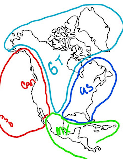

- Can = Canada with those red circles representing Hawaii. Yep, Canada is a western country.
- GT = The Greater Tribal Council of the Americas, they include Greenland.
- US = United States. They are in the east plus Quebec, Nova Scotia, and part of Ontario.
- MX = Mexico. They extend down into Central America and they have some of the island nations in the Caribbean.
- Borders are not exact, this is just to give you a rough estimate of where the countries are located and what they encompass.
GEOGRAPHY
the Greater Tribal Council of the Americas (the GT)
is divided into eleven conservatorships.
Each conservatorship houses multiple tribes, the names of the conservatorship
attempt to be as broad as possible. Encompasses much of central and western
North America
1.
Southwestern
Alliance Conservatorship (SWACon) – formed around four
corners
a.
Bosque
region – from Rio Grande east, 750,00 inhabitants
i. Albuquerque
is largest settlement, population 400,000
ii. Approved
region for Psycept residents, most live in PsyTown-ABQ
iii. Puebloan
and Apache tribes predominate
b.
Chaco
region – central area of SWACon, 600,000 inhabitants
i. Conservatorship
central headquarters
1.
Wir-Kiva SWACon municipal seat
2.
Great Kiva sacred meeting place
3.
Tsé Bit’a’í sacred landmark (Shiprock)
ii. Navajo,
Puebloans, Zuni major tribes
c.
Mesa
Verde region – northern border, 475,000 inhabitants
i. Mesa
Verde area is regional seat
ii. Ute
and Puebloans major tribes
d.
Hohokam
region – western area, 650,000 inhabitants
i. Kaibab
Canyon (Grand Canyon) and Kaibab Forest here
ii. SWACon
military base seat
iii. Hopi,
Apache, Navajo, and Puebloan tribes predominate
2.
Llano
Estacado – panhandle and west Texas territory
a.
Between SWACon and US/Texas
b.
Oneida
(Amarillo),
Lubbock, Midland/Odessa, etc
c.
Smallest conservatorship, 575,000
inhabitants
3.
Cochise
Conservatorship (CoCon) – Arizona, New Mexico, Texas,
Mexico
a.
South of SWACon, borders Mexico
b.
El Paso is a major settlement
4.
Great
Basin Conservatorship – Colorado, Utah, Idaho, Wyoming
a.
Auraria
(Denver) first Psycept settlement of the GT
5.
Plateau
Conservatorship (PlateauCon) – parts of Idaho,
Montana, and BC
6.
Southern
Plains Conservatorship
7.
Central
Plains Conservatorship
8.
Northern
Plains Conservatorship
9.
Subarctic
East Conservatorship
10. Subarctic West Conservatorship
11. Arctic (includes Kalaallit Nunaat-Greenland)
Countries – Canada, Mexico, and the US redrew
national lines to carve out GT nation lands
1.
US = eastern North America
a.
from Texas/Arkansas east to Atlantic at
a diagonal slant
b.
added Quebec, NewFoundland, and part of
Ontario
c.
gave up Pacific central and Pacific
coast territories
2.
Canada = Pacific Coast North America
a.
BC and Yukon portion
b.
added Washington/Oregon (Cascadia
province)
c.
added Nevada / California (Sierra
province, California province)
d.
added Baja California peninsula
e.
Hawaii added after new territory
3.
Mexico = Mexico and much of Central
America
a.
Gave up northern Mexico and Baja
California territories
b.
much of Central America and Puerto Rico
remain with Mexico


Comments
Post a Comment