TOG: Primer (Countries and Borders)

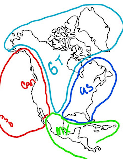
The Geography section is in the World of Touch of Gray appendix at the end of Out of Touch . However, my craptacular map is not, so I hope you appreciate my bravery in showing you my extreme lack of map-making skills. Can = Canada with those red circles representing Hawaii. Yep, Canada is a western country. GT = The Greater Tribal Council of the Americas, they include Greenland. US = United States. They are in the east plus Quebec, Nova Scotia, and part of Ontario. MX = Mexico. They extend down into Central America and they have some of the island nations in the Caribbean. Borders are not exact, this is just to give you a rough estimate of where the countries are located and what they encompass. For Invisible Touch promotion, I'll create a map of the Southwest section of North America to include some of the conservatorships and their relation to SWACon. This will probably be posted in July or August. But for now, below are the descriptors...